Rim to Reno: Take a Hidden Hike
September – October 2015
Located between Reno and Lake Tahoe, this trail offers a way to disappear from it all, without going very far.
By TIM HAUSERMAN
What is truly remarkable about the Rim-to-Reno Trail is that at each end of the trail you will find some of the busiest sections of trail in Nevada, yet in the middle there are mile upon mile of little used trail providing a true feeling of remote wilderness. Even in the middle of a summer weekend, you just might have the place to yourself. For people who have only hiked the first 4 miles of trail to Mt. Rose, or the last 3 miles near Thomas Creek, this route provides a fresh new perspective of the back side of Mt. Rose, Mt. Houghton, Church Peak and the amazing, and until this trail was built mostly unseen, heart of the Mt. Rose Wilderness.The 21-mile Rim-to-Reno Trail, completed in 2012, was a dream come true in the Sierra. It connects the Thomas Creek Trail on the outskirts of Reno with the Tahoe Rim Trail at the top of the Mt. Rose Highway. Hikers will find waterfalls, spectacular wildflower displays, and over a dozen miles of remote wilderness with magnificent mountain vistas.
The route begins at the Mt. Rose Highway trailhead with the lovely 2.5-mile tromp to Galena Falls. There is not a lot of climbing in this section, but some incredible views of Lake Tahoe and Mt. Rose. Start early to avoid the crowds, most of whom hike just to the falls. Then the real climbing begins, to a saddle, where at 3.8 miles from the trailhead you reach a junction. The Rim-to-Reno Trail goes straight ahead, while the Mt. Rose Summit trail, and the vast majority of the hikers who made it this far, go right.
Immediately, the trail changes to a remote journey through little-used wilderness. You now need to stay alert as you hike, since the trail is faint in spots because of lack of use. In fact, while many trails suffer from overuse, this one needs more hikers to take it on so that the pathway remains visible.
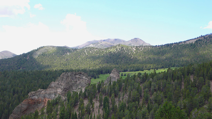
The Rim-to-Reno meanders down into a lovely bowl with fine looking specimens of lodgepole and whitebark pine, with the steep rocky slopes of Mt. Houghton reaching high above to the left. Eventually the trail bottoms out at 9200 feet, with a crossing of the sparkling, swiftly moving waters of little Bronco Creek. If you are looking for a place to camp, this would be the spot, as no water will be found again until the last few miles in busy Thomas Creek Canyon.
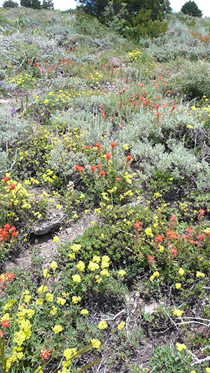
After leaving the wildflower dotted stream, the trail begins a long gentle climb to the top of the ridge at 9730 feet. As you rise, the views back through Bronco Canyon to Mt. Rose, Church Peak and Mt. Houghton just keep getting better, and the low sagebrush-covered slopes are loaded with bright splotches of wildflowers including paint brush and lupine.
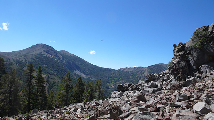
The trail rounds several rocky outcroppings, each with another fine vista, before setting out on a several-mile long nearly level traverse straight north through a dense forest. Eleven miles into the hike is a junction. Both directions head toward the Thomas Creek trailhead, but the North Loop adds an additional 2 miles to the journey.
On the South route, the trail switchbacks up through rocky terrain to the crest. From here with Reno now in sight, it is all downhill to the Thomas Creek trailhead, nearly 9 trail miles away. The first half mile is the toughest, with very steep tight switchbacks on narrow trail. Three miles from their parting, the North and South loops join again, and the trail begins switchbacking through a wide, wildflower-covered slope. The views of volcanic rock formations and the deep green of the aspen surrounding the headwaters of Thomas Creek, make this view one of the highlights of the hike. At the bottom of the slope the trail follows Thomas Creek as it meanders through aspen groves with the creek nearby for the rest of the 6 miles to the trailhead.
Plan Your Trip
Directions: The Tahoe Rim Trail/Mt. Rose Trailhead is located at the top of the Mt. Rose Highway (431), 17 miles west of Highway 395, and 8 miles east of Incline Village.
For more information, visit the Tahoe Rim Trail online.
Tim Hauserman wrote the official guidebook to the Tahoe Rim Trail, now in it’s 3rd edition. He also wrote “Monsters in the Woods: Backpacking with Children” and “Gertrude’s Tahoe Adventures in Time.” He is a freelance writer based in Tahoe City who likes to be outdoors road and mountain biking, hiking and kayaking. In the winter he teaches cross-country skiing and directs the Strider Gliders after school ski program at Tahoe Cross-Country ski area. You can find more of his work at www.writeonrex.com.