Stamps Mark the Spot
March – April 2019
Commemorative passports give Nevada roadtrips new purpose.
BY CLAIRE WHITE
There is a lot to see in Nevada—110,557 square miles of rugged, picturesque mountains, lakes, and desert. Because of the state’s large size and wide-open spaces, it can be daunting for even the most courageous traveler to figure out how to see it all, or even where to start. That is where commemorative passports come into play.
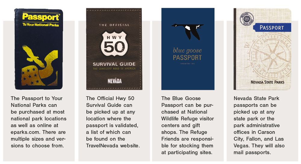
The quintessential commemorative passport is the Passport to Your National Parks. Eastern National, the organization that operates many of the national park gift shops, began their passport program in 1986. It was created to encourage visitation and provide visitors a lasting keepsake. The passport program has grown extremely popular, with more than 1.3 million passports sold to date.
That same year, the Nevada Commission on Tourism (now TravelNevada) created the Official Hwy 50 Survival Guide. Produced after a July 1986 “Life” magazine article described the portion of U.S. Route 50 (more commonly known as Highway 50) that runs through Nevada as the “Loneliest Road in America,” the state embraced the moniker and began using it advantageously. Passport holders hunt for stamps in eight towns along Highway 50 and receive a certificate of completion to authenticate their survival skills.
In 1999, the U.S. Fish and Wildlife Service joined the fun when they introduced the Blue Goose Passport. Participants collect stamps at wildlife refuges across the country. Nevada is home to 10 of the more than 560 refuges.
Nevada State Parks launched their own passport program in 2014 to encourage residents to visit parks across the state. Once passport holders collect stamps at 15 parks, they earn a free annual pass to the state park system.
Commemorative passports come in many varieties, and can facilitate trip planning giving what could be an unwieldy roadtrip a themed focus. Just choose your passport, or more than one, and get started!
COLLECT THOSE STAMPS
Nevada State Parks
parks.nv.gov
U.S. Fish and Wildlife Service
fws.gov/refuges
National Parks
nps.gov
eparks.com
Highway 50 Survival Guide
travelnevada.com
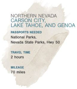 NORTHERN NEVADA
This trip explores the smallest geographic area, but what it lacks in mileage it makes up for in gorgeous lakeside views and historical treasures. The area around Carson City and Lake Tahoe has an interesting transportation history to explore at the Nevada State Railroad Museum and equally fascinating maritime heritage to witness first hand on the lake.
Begin at Washoe Lake State Park, which is north of Carson City off of Interstate 580. Washoe Lake is a shallow lake perfect for fishing and birdwatching. The park also offers equestrian facilities. From Washoe Lake, take I-580 to the Nevada State Railroad Museum, where you can collect the Hwy 50 Carson City stamp and explore Nevada’s rich railroad history. The exhibits include both model and full-size train cars, including a few you can still ride. Stop for a snack at Comma Coffee (312 S. Carson Street). The coffee, house-made pastries, and sandwiches are good for breakfast or lunch, and if it is nice enough to sit outside, you can enjoy a view of the Nevada State Legislature grounds.
Continuing onto U.S. 50, stop at Spooner Lake, the first of four sites that form Lake Tahoe State Park. Spooner Lake offers hiking, biking, and equestrian trails. In the winter, cross country skiing and snowshoeing are popular. From Spooner Lake, take State Route 28 to Sand Harbor, one of Tahoe’s most popular beaches. You have not truly visited Lake Tahoe until you take a picture of the beach’s rocky outcroppings. The visitor center is open year-round, and horse-drawn sleigh rides are offered during the winter. Backtrack on S.R. 28 to U.S. 50 to discover Cave Rock, which is a state park as well as a convenient tunnel. Continue to Van Sickle. Located near Stateline and bordering California, it is Nevada’s only bi-state park. The trails provide beautiful views of the lake as well as the surrounding mountains in both states.

From Van Sickle, say goodbye to North America’s largest alpine lake and take S.R. 207 (Kingsbury Grade) to S.R. 206 to Mormon Station State Historic Park in Genoa. The reconstructed trading post features exhibits about the original settlers, including Snowshoe Thompson—Nevada’s skiing mailman. Collect the state park stamp as well as the Pony Express National Historic Trail stamp for your national park passport. Celebrate the trip at the Genoa Bar, which is Nevada’s oldest thirst parlor and conveniently located across the street from Mormon Station.
 NORTHEASTERN NEVADA
This trip takes advantage of northeastern Nevada’s vast landscapes. There are multiple opportunities to fish and enjoy the beauty of the Great Basin. It also introduces the intrepid historical explorers who traveled this land before—the Donner party, the miners of the Ward District, Absalom Lehman, and more.
This trip begins at the California Trail Interpretive Center in Elko, right off of I-80. The center features immersive exhibits on the western overland immigrant experience including traditional dioramas, hands-on activities, and an audio-visual presentation on the Donner party. A stamp in your national park passport for the California National Historic Trail will commemorate your visit. From there, get back on I-80 and stop for a traditional Basque meal at Elko’s Star Hotel (246 Silver Street). Basque food must be experienced in its delicious, family-style glory at least once in a lifetime.
After a tasty meal, take I-80 to S.R. 227 and explore South Fork State Recreation Area, where you can catch catfish, trout, and bass while keeping an eye out for mule deer and beavers. From South Fork, take S.R. 228 to National Forest Service Road 113 to the Ruby Lake National Wildlife Refuge, where you can enjoy more fishing as well as hunting during waterfowl season. One of the most remote wildlife refuges, even by Nevada standards, the lake is a marshy oasis for ducks and geese. Note that the roads to and from Ruby Lake may be impassable during winter.
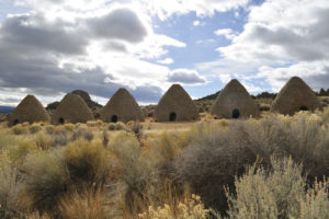
From Ruby Lake, take White Pine County Road 3 to U.S. 50. In Ely, visit the Nevada Northern Railway Museum, which offers rides on historic trains and the Hwy 50 Ely stamp. Then take the U.S. 50 to Cave Lake State Park and Ward Charcoal Ovens State Historic Park, which are across the highway from each other. Cave Lake is known for its fishing and boating. Hiking along Steptoe Creek provides a respite from the crowds. And in the winter, snowmobiling is allowed on approved roads. At Ward Charcoal Ovens, discover the history of the Ward Mining District and the ovens used to produce charcoal to operate the mines. Make sure you look up when you step inside the ovens—you can get some interesting, textural photos this way.
Continue on U.S. 50 to Baker and Great Basin National Park, Nevada’s only exclusive national park. The park is a spectacular showcase of the Great Basin’s diversity—explore desert, alpine lakes, a limestone cave, and 13,000-feet high Wheeler Peak all in one park. At the Great Basin Visitor Center, get your Hwy 50 Baker stamp. Then at Lehman Caves Visitor Center you can collect your national park passport stamp. Tour the caves (make sure you take a picture of the cave bacon), wander the bristlecone forest, and if you want to end your journey on a high note, hike to Lexington Arch or Wheeler Peak.
 SOUTH CENTRAL AND EASTERN NEVADA
This trip is the longest, beginning all the way on the western edge of Nye County before crossing through Clark County into Lincoln County. The route helps you to appreciate the natural oases in Ash Meadows and Pahranagat all the more after traveling across so much arid terrain. Lincoln County provides a lesson in contrast as you explore three of its five state parks and see everything from sandstone to fruit trees to the Eagle Valley Reservoir.
Starting at Ash Meadows National Wildlife Refuge northwest of Pahrump, pick up Blue Goose and Death Valley National Park stamps (make sure you visit Devil’s Hole, which is officially part of Death Valley). The visitor center features an exhibit on this desert oasis in the Amargosa Valley and provides a boardwalk out to Crystal Spring. Also check out Point of Rocks and look for the endangered Ash Meadows Amargosa pupfish in Kings Pool.
From Ash Meadows, take S.R. 373 to U.S. 95 through Las Vegas to U.S. 93 to get to Pahranagat National Wildlife Refuge. Stroll around Upper Lake, which offers multiple viewing areas for birds. Look out for various geese, ducks, egrets, and herons. Depending on the season, you may even see a pelican or a bald eagle. Continuing north on U.S. 93, stop for breakfast or lunch at Windmill Ridge in Alamo. Their pies and cookies are unbelievable, as are their chipotle pork ribs.
From there, the focus shifts to state parks. Continuing north on U.S. 93, Kershaw-Ryan State Park is just 2 miles south of Caliente. Enjoy a picnic and a game of horseshoes under the shade of cherry and apricot trees. In the spring and summer, you can call ahead to plan a tour of Elgin Schoolhouse, built in 1922, and located south of Kershaw-Ryan. The school’s teacher lived onsite, so a tour includes a peek at the small apartment as well as an opportunity to peruse the quaint schoolbooks. The schoolhouse has its own stamp, even if the state parks passport does not have a separate page for the site.
From there, continue on U.S. 93 to Cathedral Gorge State Park, outside of Panaca. The spires that inspired the park’s name were formed of silt and volcanic ash over millions of years, and they form gorgeous slot canyons and dramatic cliffs that beg exploration and are great for photo ops. Make sure you look up, or back—you never know when you will find the perfect angle. Continuing north on U.S. 93 to S.R. 322, check out Spring Valley State Park. There is something for everyone: history, hiking, and fishing for rainbow and brown trout. Hike the trail that begins behind the historic stone cabin, pass the old root cellar before ascending a few hundred feet onto the red volcanic tuff, and then descend back into the valley. If you visit in the summer, the stone cabin is also open for tours.
 SOUTHERN NEVADA
This trip explores the greater Las Vegas area before heading to Laughlin.
You will see some of the most popular recreation areas in the state—Valley of Fire and Lake Mead—but it also introduces some of the quieter areas southern Nevada has to offer.
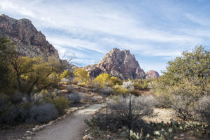
West of Las Vegas, located outside of Blue Diamond, Spring Mountain Ranch State Park (6375 Highway 159) is an oasis in the Spring Mountains. Enjoy the trails and tour the ranch house, once owned by Howard Hughes, though he never lived there. Then take S.R. 159 to Clark County Route 215 and U.S. 95 to Desert National Wildlife Refuge. The Corn Creek Visitor’s Center offers a series of short loop trails exploring the flora and fauna of the Mojave Desert. A refugium stocked with endangered Pahrump poolfish hints at the extensive work undertaken at the refuge, which is the largest outside of Alaska.
Head south on U.S. 95 to the Old Las Vegas Mormon Fort State Historic Park. Surprisingly, the Old Mormon Fort, which was the first European-American settlement in the area, is the oldest surviving structure in Nevada. From the oldest building, head north on I-15 to the oldest state park, Valley of Fire. As you hike through the gorgeous red sandstone, be on the lookout for petrified logs, prehistoric petroglyphs, and big horn sheep. The rock formations are some of the most photographed in the state. Elephant rock and fire wave are must-have photos, but some of the less recognizable formations, like the beehives, are also beautiful at the right angle. A portion of the White Domes trail is a favorite among Trekkies; you can see a slot canyon where scenes of “Star Trek: Generations” were filmed. And if you are willing to venture off the beaten path, walk out to the memorial for Sergeant John Jay Clark (no relation to Clark County), a Civil War veteran who was honorably discharged after getting shot in the hand and contracting typhoid fever. He later died of thirst on this stretch of the Arrowhead Highway.
The northern edge of Lake Mead National Recreation Area is just 2 miles from the eastern boundary of Valley of Fire. There is a lot to see and do, but stop at the Alan Bible Visitor Center to get your stamps. From there, head into Boulder City for a Dole Whip at Chilly Jilly’z (1680 Boulder City Parkway). Then take U.S. 95 to S.R. 163 and head to Big Bend of the Colorado State Recreation Area in Laughlin to enjoy swimming, hiking, or boating along the Colorado River.
PLANNING YOUR PASSPORT ADVENTURE
Together, these passports provide opportunities to collect more than 50 stamps across every region in Nevada.