Ghost Railroads
March – April 2017
EXPLORING THE GHOST RAILROADS OF CENTRAL NEVADA
HISTORIC SITES LAY TRACKS TO THE PAST.
BY JIM PRICE
 “Choo, Choo!” I know it seems child-like, but every time my wife and I are driving along what we know is an abandoned railroad grade I just can’t help myself. We ride through cuts and overfills that were built more than 100 years ago for railroad lines that brought hopeful prospectors of all kinds to the new mining bonanzas in central Nevada, hauled out processed ore, and brought in needed supplies for burgeoning cities.
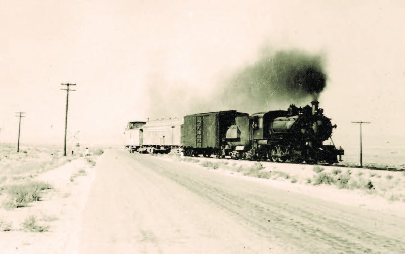
Between 1904-07, four different railroad companies optimistically laid no less than 500 miles of shiny new rail in order to reach the boom cities of Tonopah, Goldfield, and Rhyolite. Imagine the activity level in such a short time: roadbeds graded, trestles built, ties and rail laid, and multiple depots constructed to service the residents and businesses of each city. This had to have been an amazingly exciting time, and the railroads were certainly a key element in the growth of these boomtowns.
But by the 1920s, ore production was falling off and the booms were going bust. It was quick. One by one, the railroad lines were scrapped until by 1947, there were no more rails at all in central Nevada. Fast forward to today. Surely, one would think, there should be some really interesting remnants of these now “ghost” railroads. And indeed there are!
ALL ABOARD!
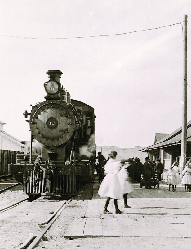
Tonopah boomed first, and the Tonopah Railroad was built from Sodaville (near Mina) to Tonopah in 1904. Next was Goldfield: the Goldfield Railroad was built from Tonopah to that new boom in 1905, and soon thereafter the Tonopah & Goldfield Railroad (T&G) was born with the merger of these two lines.
Then in 1906 and 1907, it was Rhyolite and Beatty’s turn. Three separate lines were built to the new Bullfrog Mining District: the Bullfrog Goldfield (BG) south from Goldfield; the Las Vegas & Tonopah (LV&T) north from Las Vegas to Beatty and on to Goldfield; and the Tonopah & Tidewater (T&T) north from Ludlow, California, to the Beatty area, spanning almost 200 miles.
By the end of 1907, all of these railroad lines were in place, operating with a full head of steam, so to speak, and it would have been possible to ride by rail all the way from Las Vegas to Reno. Shipment of goods and transportation of passengers to and from any point in the U.S. was available.
T&G ROUNDHOUSE AND TURNTABLE AT MILLER’S
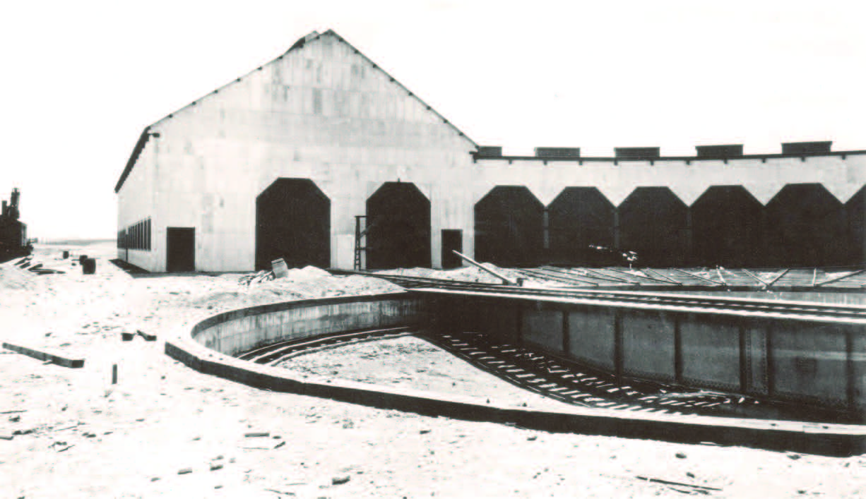 In about 1905, the T&G Railroad built a large roundhouse and turntable at Miller’s, some 10 miles west of Tonopah, on flat ground, as Tonopah was too steep and hilly for a large service yard. Miller’s was also a major processing site for ore from some of Tonopah’s rich mines. An eight-stall roundhouse was built, adjacent to a 90-foot diameter turntable. This allowed the turning of the locomotives and coal cars before backing them into (or driving them out of) a “home” for service and/or protection. Service pits existed underneath the tracks inside the roundhouse allowing mechanics easy access to the underside of the locomotives.
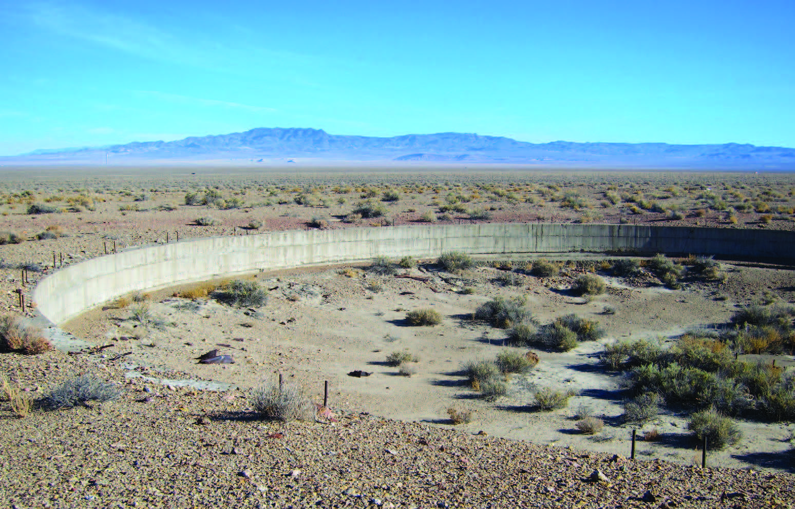
What’s left to see today are the extensive foundations of both the roundhouse and turntable. Owing to the ground being level and very little vegetation in the area, the concrete foundations appear to have been poured yesterday.
Getting there: Go to the rest area on U.S. Routes 6 and 95 about 10 miles west of Tonopah, turn south on an unmarked dirt road, and proceed about 1 mile. Turn left upon arrival at power lines that run perpendicular to the road, and drive a short distance. GPS coordinates: N 38 07.696, W 117 27.208
T&G TRESTLE AT TONOPAH HISTORIC MINING PARK
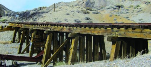
As Tonopah is located in a fairly narrow and steep canyon, the T&G Railroad built a spur line into town from the area around Miller’s down the hill. A stylish depot was constructed (sadly it burned down in 1980), and additional side tracks were built to various mines in the area. The access spur to several major mines, such as the Mizpah, required construction of a wooden trestle. Fortunately, this wonderful example of railroad bridge construction has been preserved at its original location inside the Tonopah Historic Mining Park. The Mining Park is a must for travelers to Tonopah, and the trestle is an added bonus for railroad buffs.
Getting there: Start at the Mizpah Hotel—located on the corner of U.S. 95 and Brougher Avenue—turn north on Brougher, and follow the signs up the hill to the mining park. The area’s history, including that of local railroads, is also well exhibited and interpreted at the Central Nevada Museum in Tonopah, about 1 mile east of the mining park on U.S. 95.
“E-TICKET RIDES” ON RAILROAD GRADES IN AND AROUND GOLDFIELD
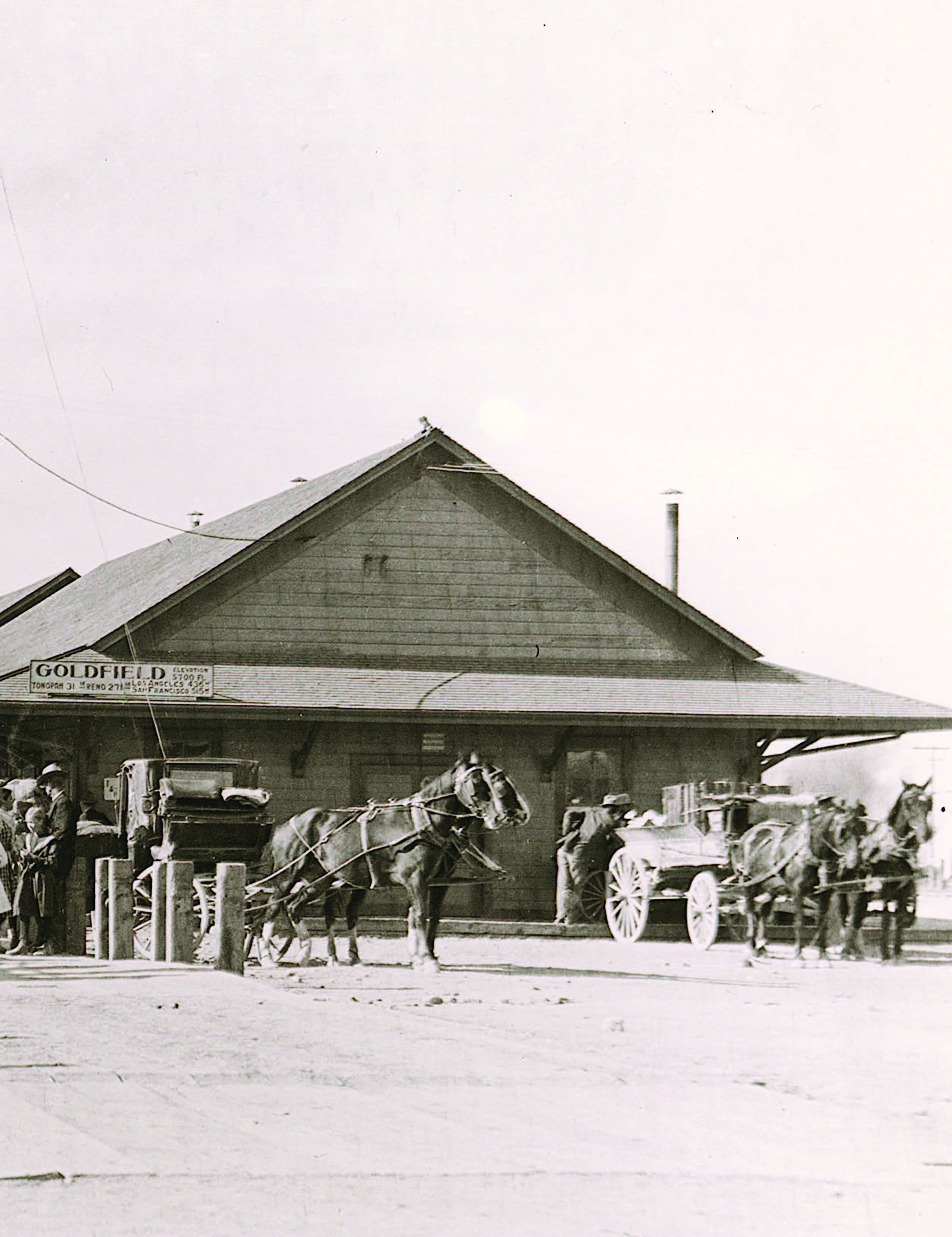
 I have to admit to being somewhat partial to Goldfield. My wife and I own a vacation home there, and we have some very close friends in town. But when you see amazing structures like the Goldfield Hotel, the Esmeralda County Courthouse, and the former Goldfield High School, you get a sense that something special must have happened here back in the boom days. And indeed it did. Three different railroad lines operated in Goldfield, each with its own railroad yard, and there were miles of tracks in Goldfield and the surrounding areas. There is distressingly little left from those days of prosperity and the bustle of thousands of residents. But there are a few must-see places.
First, visit the Bullfrog Goldfield Railroad yard. This yard would have been a busy place from its construction in 1906 into the 1920s. It’s located about one-half mile north of U.S. 95 on Fifth Avenue, across the street from the famous Santa Fe Saloon. The owner of this yard has brought in a wonderful display of a period steam locomotive, and two boxcars that originally ran on the Tonopah & Goldfield Railroad. Initial construction has been done on replicating what was a two-stall car barn for the railroad rolling stock. Two nearby miner’s cabins, a wrecked vintage automobile, and a railroad car, all from the early 1900s, add to the nostalgic scene. Please note that this is all private property, so please enjoy these scenes from the street.
Now comes the “E-ticket ride” part. One can drive on segments of what were the LV&T and BG grades for several miles to the north and east of Goldfield. These “dirt freeways” can be driven by just about any vehicle, so don’t be shy.
 Getting there: Start at the BG yard described above, go north a short distance on Fifth Avenue, and turn right at the sign pointing to Diamondfield. This road will head out to the northeast, passing by two of the remaining mining headframes—the larger one belonging to the Florence Mine. Soon after, the road bears slightly left and merges with another road from the right. You are now on the BG railroad grade! Follow this further to the northeast, and note the LV&T grade up the hill to the left. At the top of the pass, you can continue straight ahead and follow the BG grade to a wonderful spot where there used to be a trestle. GPS coordinates: N 37 40.652, W 117 11.540
Or you can turn left, go a couple of hundred feet, turn right, and now you’re on the LV&T grade. You can drive this for several miles. Once you get out there a ways, you can look around and sense that, except for the road you are on, the area looks exactly as it would have more than 100 years ago! I find that to be uplifting. And this is one place where I say “Choo, Choo!”
At about 4 miles, the “dirt freeway” ends, and you need to reverse course. As you come up the gentle grade, think about the optimism that must have been felt by early arrivals into Goldfield when this line was opened in 1906. As soon as you get to the top of the hill, continue straight, and you’ll see the city off to the left. In the boom days, this would have been a scene of frenetic activity in both the mining district and in the city. Continue on for another mile or so, then head left and back into Goldfield.
RHYOLITE’S BEAUTIFUL LV&T DEPOT
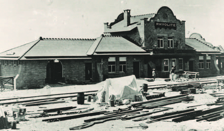
I remember the first time I saw this building many years ago. I was looking around the rather empty townsite and thinking “how the heck did this get here?” All four of the railroad lines that ran in central Nevada built structures of various kinds to service both the needs of the railroads themselves and, of course, their customers. A primary interface to those customers was the passenger and freight depots—the airports of yesteryear. LV&T built particularly attractive depots, and fortunately the one in Rhyolite has survived for all to enjoy today.
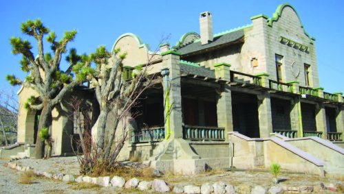
Ready for operation in 1908, the beautiful Mission Revival-style station initially serviced a busy, bustling city. But it turned out that the Bullfrog mines were nowhere near as productive as had been hoped, and Rhyolite became the ultimate example of a boom and bust city. The first train arrived into town in December 1906; the last one left less than 12 years later in 1918. This depot building has survived thanks to having several other “lives” including being a casino. It presently belongs to Bureau of Land Management, as does the entire townsite, and is looked after by a resident caretaker of Rhyolite. One can thoroughly investigate the outside of the building but cannot go inside.

Getting there: To see this truly wonderful train station, head west from Beatty on State Route 374, and go four miles to the well-marked right turn to Rhyolite. Stop at the bottle house and pick up a town map. The depot sits at the far northern end of town. You’ll also see the remains of a Union Pacific caboose adjacent to the depot. Now you know how the heck this building got here, but do look around and think about what would have been going on here more than 100 years ago compared to today.
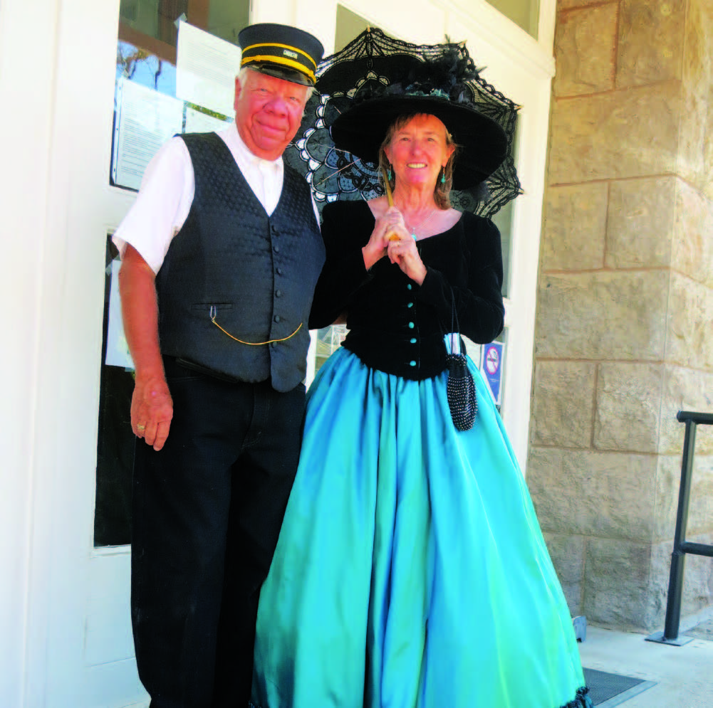 Meet the Conductor!

For more in-depth information on this topic, check out the author’s book “Discovering the Ghost Railroads of Central Nevada.” The book is available in some stores in central Nevada, especially in Tonopah and Goldfield, and on Amazon.
T&T MURAL IN BEATTY
As noted previously, the Beatty/Rhyolite area was the confluence of three railroad lines: the BG, LV&T, and T&T. There was so much railroad activity in Beatty back in the day that it was nicknamed “The Chicago of The West.” But when one visits Beatty today, the only two obvious reminders of its train-related heyday are a Nevada state historic sign, and a beautiful mural painted on the side of a building near the original location of the LV&T depot.
RIDE THE GHOST RAILS
So, take a day or take a week to explore these and other remnants of the railroad glory days of Tonopah, Goldfield, Beatty, and Rhyolite. For those who are already ghost town enthusiasts, learning about the railroads that served those towns takes nostalgia about those boom years to a new level.
Getting there: The sign and the mural are located near the corner of U.S. 95 and Amargosa Street on the southeast side of Beatty. Local artist Laura Cunningham completed the full-color mural—10 feet tall by 90 feet long—in 2008. The artwork is stunning in its size, detailed subject matter, and vibrant colors. The depot that is depicted stood about 100 yards to the south. About five blocks away, on S.R. 374, south of the junction with U.S. 95, is the Beatty Museum, truly a treasure trove of local area memorabilia and history.